Sendero Group Travel Blog

Follow Sendero travelers on their adventures using accessible GPS.

Friday, October 19, 2012


hello from the NFB state conference in Los Angeles


Things are pleasantly busy at the NFB State Conference exhibits this year. Lots of interest of course in when our Seeing Eye GPS iPhone app is coming out.
I have given some folks a sneak peak.

Our neighbors on one side are Sweetman Systems and on the other side is Audio Eyes, a video description business.


Saturday, October 06, 2012


GPS treasure hunt today in Davis
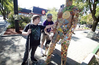


Michael May, right, CEO of Sendero Group, and William Jeffries of Roseville reach the a statue at Fourth and G streets Saturday morning on a scavenger hunt in downtown Davis. Image copyright Davis Enterprise.We had a blast today exploring down town Davis California and nearby nature areas using accessible GPS. Eleven year-old Nicky said his highlight was finding things faster than his teacher. William was a natural from the outset. He has an Apex but never knew about the GPS until today. He was navigating without help by the end of the day. It was fun for me to hear the students discussing the facts they learned about the plants from the audio files associated with each of the plaques in the Arboretum.
This story, Showing the Way, was featured in the local Sunday newspaper, the Davis Enterprise.

Thursday, October 04, 2012


Richmond Civil War exhibits


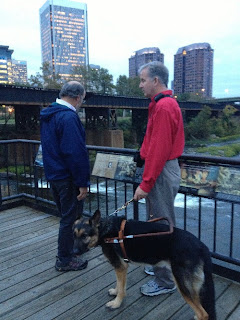
On Monday evening, after our GPS tours with the O&M instructors, we hooked up with some guide dog instructors in search of Civil War history exhibits.

Mike and Lukas Frank reading the Civil War quotes
Just south of our hotel on 5th Street, we found a long pedestrian bridge with Civil War quotes written on the flooring about every 6 feet. Lukas Frank read me all the quotes. I should have captured them on the POI I set for that bridge over the James River. We did grab a photo.

From there, we found another long pedestrian bridge that took us to Belle Isle where the Yankee prisoners were kept captive. There are quite a few monuments and plaques in the area. Definitely worth exploring another time.

Mike

Tuesday, October 02, 2012


the joy of exploration by Mike May


The fun aspects of exploring with GPS come in many varied ways.

Today at the O&M conference here in Richmond, Katie and I did 2 lectures in the hotel and two walk-about sessions with the O&M instructors. The fun part is seeing how the folks start to have the lights go on and picturing how this GPS would work for their students.

My last group was a bit wild, quite chatty and not really into following the plan I outlined for them. Instead, we went in search of a folklore Center, quite a ways away. It turned out to be closed but the GPS guided us right to the door. I'd warned them not to expect this. Fun when it actually happens.

On the way back to the hotel, we came across a bunch of people on the sidewalk and I was informed this was an Obama campaign center. We stopped and chatted with the folks who wanted us to take lawn signs, not too practical to post at our hotel rooms or to carry on an airplane.

One gal was trying to get by us but she was afraid of my Seeing Eye dog. Her colleagues teased her saying it's a Service dog, don't be a frady cat.

She finally slipped by and next thing I know, she is asking me if she can touch the dog. Very tentatively, she touches Tank. Being the chick magnet he is, he gives her a lean and now she is in love.

She asks if she can get a camera from her car to take a picture. I agree to wait and she returns in 5 minutes to snap photos of Tank and me.

Perhaps she didn't want me to feel left out because then she says, would you mind if I gave you a hug. Sure, why not.

So, a coincidental stop while out exploring with GPS ended up with a fun social interaction with a bunch of like-minded Obama supporters and one serious dog convert. One of my other sayings besides "Its Better to Travel Hopefully than to arrive" is "The People Make the Places".

Mike

Monday, October 01, 2012


S/COMA: Seeing the Whole Picture! O&M Conference


Katie and I had five Accessible GPS and Maps sessions over two days here at the SOMA/COMA Conference.

We were able to capture a photo of one group from the GPS Exploration Tours.


Mike and O&M Instructors listening to Accessible GPS at an intersection corner


Archives

August 1997   January 1998   August 1999   December 1999   January 2000   September 2004   October 2004   November 2004   December 2004   March 2005   May 2005   July 2005   August 2005   September 2005   November 2005   May 2006   June 2006   August 2006   September 2006   October 2006   November 2006   December 2006   February 2007   March 2007   April 2007   May 2007   July 2007   August 2007   September 2007   October 2007   November 2007   December 2007   January 2008   February 2008   March 2008   May 2008   June 2008   July 2008   August 2008   October 2008   January 2009   June 2009   July 2009   August 2009   September 2009   October 2009   November 2009   December 2009   January 2010   March 2010   April 2010   July 2010   October 2010   December 2010   February 2011   May 2011   July 2011   September 2011   October 2011   November 2011   January 2012   February 2012   March 2012   April 2012   May 2012   July 2012   August 2012   October 2012   November 2012   December 2012   January 2013   March 2013   June 2013   July 2013   August 2013   September 2013   October 2013   November 2013   December 2013   January 2014   March 2014   April 2014   August 2014   September 2014   October 2014   November 2014   December 2014   February 2015   July 2015   August 2015   September 2015   November 2015   December 2015   January 2016   January 2017   September 2018   November 2018  
This page is powered by Blogger. Isn't yours?