Sendero Group Travel Blog
Follow Sendero travelers on their adventures using accessible GPS.Monday, September 19, 2005
WayFun 2005, Maine, Wrap Up
This third Way Fun adventure shares key elements of independent travel with the previous two years in Ireland/Scotland 2004 and the California Gold Country in 2003. Six students this year added a high level of enthusiasm and energy to 5 days exploration in Portland and Bar Harbor Maine. Sponsored by five organizations, Sendero Group, HumanWare, Adaptive Technology Consulting, the Seeing Eye and Delorme, these students, along with 25 others, tested their limits and the full range of orientation and mobility skills while learning GPS wayfinding technology. The students gave me a break this year and wrote the Blog entries for each day. See their Blog links below. As I look back over the past five days, here are some of my thoughts and feelings.
We ate incredibly well beginning with a group dinner at the floating Dimillo’s restaurant in Portland to kick off the event Wednesday. I am quite sure most of us don’t eat elaborate dinners five days in a row. When you have walked all day and then look at the plethora of restaurants in the BrailleNote GPS database, it is required to conclude the day with a food adventure.
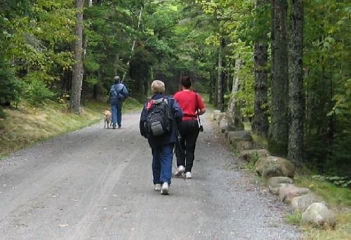
For the first 4 days, we explored in groups of 4 to 6 people. In this way, the experienced users could help the novices including the Seeing Eye instructors, while they in turn helped with mobility issues and learned how accessible GPS could integrate with a Seeing Eye dog. The more intrepid travelers could speed up the slower ones and the slower participants could teach the others a measure of caution and self preservation. Keep in mind that we are traveling and getting lost among streets we have never explored before. A very complex intersection with islands was the first intersection we would come to outside our Portland hotel. In Bar Harbor, we had a busy road with a narrow shoulder for a mile and a half between the hotel and town. The participants shared a high motivation to learn and to push their limits but they ranged in ability on both the orientation and mobility fronts. Our mission was to set the bar high so everyone would be challenged to improve in both areas.

To test my own limits, I try to do something solo each Way Fun year. I love being the leader and sharing the power of GPS and good mobility with others. It is important that I challenge myself too while taking a break from being the organizer.
On our last full day, I was torn between the Carriage ride and a challenging hike with a couple of the students. I decided to try and do both. We hiked along the smooth carriage road from Jordan Pond to the Wildwood Stables and I rode in the carriage back to the pond with 6 of our group. While they stopped at the Jordan House for a spot of tea, I raised Adam and Stacy on the radio and set out on foot at a fast clip to hook up with them.
Adam radioed me his lat/lon position, which I entered into my BrailleNote and set as my destination. They had a one-hour head start so it was going to be tough to catch them.
The initial walk around the east side of the pond heading north was smooth. My dog Miguel was threading me through the trees from 3 to 5 miles per hour. I knew this by pressing S for speed on my GPS. I kept checking in with Adam from time to time on the radio, hearing about how they left the shoreline trail and were trying to figure out a steep side trail. My goal was to find that same trail.
My shoreline trail crossed 5 narrow wooden bridges and then became very rocky. I got so caught up in clambering to and fro behind Miguel that I finally discovered I had past the Adam and Stacy trail by .85 miles. I didn’t want to deal with walking back over the boulders behind me so I told them not to wait and I would continue around the pond and meet them back at base.
When the boulders ended, a narrow wooden walk began. It was made up of two 8 by 2 inch planks. It ranged from 6 inches off the ground to 3 feet. Sixteen inches is not wide enough for a dog and person to walk side-by-side so I angled behind Miguel and gingerly stepped along. I slipped off this precarious boardwalk a couple times including one full-fledged sprawl on my back. I was very glad to have the radio so I could call for help if I got hurt but mostly so we could trade play-by-play details about our respective hiking adventures.
The wooden walk carried on for three quarters of a mile. I thought it would never end and was immensely relieved when it finally transitioned to a smooth shoreline trail. Shortly there after and 4 miles since I set out, I reached the Jordan House. Adam and Stacy arrived a few minutes after I did. We toasted a pint to our mutual independent adventures. Although we love our sighted friends dearly, these hikes were highlights for us because we accomplished them on our own.
I was really proud to hear of other solo travels. On the first night, Adam and Jay got separated from the group heading back from Dimillo’s and had to use the GPS and their wits to find the way to the hotel on the very first night of the trip. Mark and Angela weren’t willing to wait for those of us in quest of ice-cream and also found their way back alone. Denna went Kayaking on her own because nobody else was going and she was bound and determined to go sea kayaking. Ilona from the Netherlands is a beautiful quiet spirit, seldom at the head of a group but always arriving at the destination with or without others. I sometimes felt like we had created monsters as the students and others charged off this way and that, reveling in the opportunity and ability to check out anything and everything. One never quite knew where a blind couple, Paul and Kathy, would turn up. I loved hearing others like Jamie get excited about points of interest we would pass if only because of a peculiar name. Jamie shares my child-like wonderment just to be able to know what is nearby.
When I awoke early this morning, I discovered a beautiful sunny day and wished I could stay longer. I was tickled to hear one of our new participants, David Egan, was one step ahead of me. He changed his flights to explore Bar Harbor a few more days on his own. It is good to know as we all sadly head home, that David was inspired by the group along with his newly developed GPS skills and will be creating his own independent way and fun while most of us return to work or school. As we hung out in the airport for our respective flights, we were already brain storming about places to go next year or sooner, Alaska, Australia, Italy, or maybe Prague for WayFun 2006. Best of all, we would be charging just a bit faster through our day to day life inspired by our new friends and wayfinding skills.
Sunday, September 18, 2005
Sunday: Stacy's perspective
It was a very empowering experience...just us and our GPS units against the world! We started out on a trail that wound along the perimeter of the lake, which was about three miles, but we decided to leave that trail and check out the Deer Brook Trail. The Deer Brook Trail literally required us to scramble up the side of a waterfall. When we first started on that trail, we thought we had made some kind of a mistake, there didn't seem to be any trail, it was just a bunch of rocks heading straight up. An Irishman came down the hill and told us that this was indeed the Deer Brook Trail. He said that he'd fallen twice on it and he convinced us to turn around and head back to the main trail. We were on our way back, when we stopped and decided that we didn't want to give up so easily, especially based on a guy’s preconceived notions of what we could handle who we didn’t even know. So, back up the trail we went.
After a few minutes of scrambling up the rocks, we began to feel pretty confident again...when, all of a sudden, the trail required us to walk across a bunch of boulders that crossed the waterfall. Again, we considered turning around, but I scouted ahead with my cane, using it to feel the shape and size of each rock and determined that it was indeed safe for us to proceed. We took the rocks very slowly. I would use my cane to find the next rock, step onto it, and then pass it back to Adam (who uses a guide dog) and then he would use the cane to feel his way too.
After we had safely crossed the waterfall, a group of people on the other side told us that the trail was dangerous ahead and that we should go back. We considered their suggestion, but again we decided that we would only turn back once WE had decided that we couldn't do it anymore.
So, we continued climbing again. But eventually we got to a point, where we just couldn't figure out where the trail continued. At this point the trail was just a bunch of rocks going straight up the hill, but even the rock trail seemed to disappear into the foliage and the side of the hill. Just as we were about to go back, we ran across a group of tourists who showed us back to the trail. The trail crossed the waterfall on some rocks again and then it was another steep climb up to the carriage road. We walked on the carriage road back to the Visitor's Center, grinning like idiots the whole way. We were so happy that we persisted and hadn't turned around.
The GPS was very useful to us throughout the hike, as we were able to drop waypoints along the way like electronic virtual bread crumbs. If we had gotten lost or discovered that the trail was more than our skill level allowed, we could have easily gone back the way we had come. The GPS was also useful to us once we had gotten to the top of the Deer Brook Trail, as it helped us to get back to the Visitor's Center without a problem.
To top off the day, once we had gotten back into town, we stopped at Ben and Bill's Chocolate Emporium. Who could ask for more than Fresh air, a challenging hike, camaraderie and chocolate?
Stacy Cervenka, Minnesota
Way Fun Sunday: Denna's Kayaking Adventures
Of the many outdoor activities of which one could partake, I chose kayaking because it was the most economical way of doing something physically active and surrounding myself with the sounds and smells of the natural environment. Sometimes as a blind person, we hear about pictures or other's experiences, but we often lack a full appreciation of the ambiance of the environment without exploring it ourselves.
The instructor's from The Seeing Eye dropped me off at the Kayak location at approximately 3:30 pm. Surprisingly there was little question of my safety solely based on the fact that I am blind. I think that was due to people seeing a number of blind individuals for a few days moving within their city with a sense of confidence and assertiveness. Once I charged my debit card and signed the legal document of liability, I put on the necessary gear of proper Maine kayaking. I was paired with a gentleman from Vermont in a tandem Kayak which was broader for more stability. In this particular boat, the front paddler maintained the speed of the team, and the second paddler in the rear steered with the rudders located near your feet. I was more comfortable in the front seat of the boat due to my inexperience in steering a kayak in waters that could contain a number of buoys and other boats.
We moved steadily around the smaller uninhabited islands in Bar Harbor. It was great to hear the surf hitting the rocks along the shoreline of these islands. I could hear the fish jumping out of the water only to be caught by sea gulls waiting for unsuspecting fish. My partner conveyed his emotions when seeing the surf, the seals popping their heads in and out of the water, and the emerging sunset which had eluded us since we arrived. This kayaking experience made the WayFun trip a once in a lifetime experience. The natural sounds of the sea, the movement of the boat, and the cleanliness of the environment, are imprinted in my mind forever.
I mentioned earlier that it is hard to imagine the meaning of a word or phrase without experiencing it for oneself if you cannot see. For me, the words "wake," "seaweed" and "surf" fell into this category. Of course, I knew how to use these words in a literary sense, but today was the day where the real world gave meaning to literal definitions. For instance, I understood what the word "wake" meant, but could never solidify the actual image in my brain. While we were out on the water, a Whale Watching boat was passing us by several hundred feet. I could feel the rolling waves sent out from the boat. The kayak rocked up and down which indicated the mass of the boat. That was amazing!
After finishing the tour, I removed all of the gear like the water proof boots, the kayak skirt which kept the water from getting inside of the boat, and the life jacket. The other six kayakers thought enough of the meaning of this tour, to collect some sea life like a starfish, a sea urchin, a clam, some opened and closed muscles, and some clean seaweed. I now have a clearer picture of what our sea floor looks like with the myriad of life forms dotting the ocean floor.
Denna Lambert, Greenbelt, Maryland
Way Fun Sunday: Brian's Perspective

For the “early birds’” group consisting of Carl, Elaine, Chuck, Jamie, and Brian, Sunday became no ordinary picnic in the park. The day began in the foggy early morning because our group boarded a ferry with the destination set for Yarmouth, Nova Scotia, Canada, 110 miles East according to my GPS. We docked around 11 AM.
As a result of three dog guides in our party, the tour company provided us with our own van with the most well-informed and friendly tour guide named Calvin. While we drove along the streets of the Yarmouth area exploring the Nova Scotia maps with our GPS units, Calvin explained that he wore three hats in the community: lobster fisherman, municipal alderman, and of course, tour guide. With this varied background, you can imagine how much information Calvin shared with our group about the sordid history of the area including the struggles between the British and the French Acadians, and the intricacies of lobster fishing.

Stops along the tour included St. Anne’s Catholic Church dating back to 1799, a wind farm with 17 massive mills, and an inactive lighthouse at Acadia Village. At lunchtime, we sampled a traditional Acadian dish called roppie pie, which consisted of potatoes and chicken covered with molasses. For dessert we enjoyed both bread pudding and a molasses cookie.
Before returning to the ferry for the 3-hour ride back to Bar Harbor, we had the opportunity to examine an old wooden lobster trap, and as a souvenir, Calvin gave us wooden pegs used in the past to prevent lobsters from opening and closing their claws.
All in all, our trip to New Scotland (Nova Scotia) proved to be an exciting and worthwhile way to spend the day.
Interesting trip tidbits:
Charles learned that his last name, “LaPierre,” is Acadian and not Quebecois.
Tour Guide Calvin is eleventh generation D’entrmont (important historical figure of the Yarmouth area).
“Acadia,” formerly Arcadia is from Greek mythology meaning “beautiful land.”
Many Acadians relocated from Nova Scotia to Louisiana in the mid 1700s (ancestors of present-day Cajuns).
The dual-hull catamaran is capable of going 55 miles per hour but I only saw it get as high as 38 on my BrailleNote GPS.
Brian Quintana, Albuquerque New Mexico
Saturday, September 17, 2005
Bar Harbor Day 2
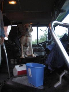
At lunch we talked about taking the island's free shuttle, for a little experience with GPS from a vehicle. When Mike contacted the shuttle company and explained what we wanted to do, they offered to set us up with a bus for a tour of Arcadia National park. This bus tour would prove to surpass our expectations. In many bus tours, one can expect to be told about various attractions, but seldom does this allow one to engage in the environment in which you ventured to see. This tour guide understood the kind of information we sought, for both the sighted participants, and most importantly, the blind GPS users. We all boarded the bus, but we quickly learned that the bus was not going anywhere. It was experiencing transmission difficulties. Never fear, the Island Express manager, Bob, ensured us that we would be underway right away. Our driver, Jeff, was incredible in keeping everyone's spirits high and up beat. We were on a working bus within 30 minutes. As we drove along, it was fascinating to hear an army of keynote synthesizers announcing the streets, and various points of interest along the way including many trail heads.
Our first stop was the Precipice Trail. For those who were most adventurous, including our leader Mike May, we climbed a few feet on a rock that sloped at a nearly vertical ascent. A few of us also learned that human beings weren't properly or naturally equipped with suction points that would allow us to climb slippery wet surfaces. Mike slid down the rock several feet, with his Seeing Eye dog Miguel along side.

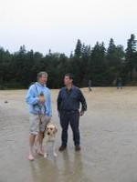
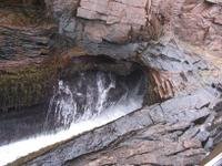
Once we all regained our bearings and land-legs, we drove to sand beach. Of course, the name doesn't indicate any unique features, but for Maine it indicates one of only a few sandy shorelines along the eastern shore board. For the experienced eastern coast travelers, the waters of the coast would be terribly cold and not suited for swimming. But for the rest, they simply removed their socks and shoes, and ran towards the water. Of course, the four legged participants agreed with the idea to go for a little swim. It is safe to say that every one felt a sense of youthful enthusiasm and spirit. It should also be noted that for many of the participants, this location marked the first and hopefully not the last visit to the beach. Among the many stops in our day trip was Thunder Hole. It can be best described as a rock with cavernous holes created by thousands of years of water erosion that causes the water to crash into the cavern and thunder outside of the rock.
From the sound of crashing waves we moved on to the serenity of Jordan Pond. Some of us purchased items in the gift shop and others discovered the Geo Cache near the pond called, “She dearly loved this spot.” We considered having dinner at their restaurant but decided to head back to down town Bar Harbor where there were more options. Most of us, including nine dogs, ended up at 2 cats for meals ranging from lobster to chicken.
Around 9:30, our GPSing was still not over for the day. We had to get back to the Bar Harbor Regency Hotel where we were staying, 1.4 miles from this part of town. We plugged in that destination and we headed out in small groups, some taking a taxi, most walking along the narrow shoulder of the busy Eden Road. It was an excellent way to walk off a big meal and to let the dogs work. We made it back in record time as the dogs were motivated to get their own dinner. It was pretty incredible team work to explore the island for a day with our dogs or canes for mobility along with the GPS for orientation and sight seeing. The fact that we ended up with a private tour by our newly discovered friend, driver Jeff, was due to local hospitality, good luck and ingenuity. We saw, heard and felt Bar Harbor in ways that few tourists can. There was no way the rain could dampen our spirits or resolve so some of us took a swim at the hotel pool to wrap up the day and to discuss the next. We discussed the next day’s possibilities including a ferry trip East to Yarmouth Nova Scotia for those who didn’t mind rough seas and getting up at 6:30, only 7 hours hence. Dena and I planned to sleep in a bit and to do more exploring of Bar Harbor.
Adam Rodenbeck and Dena Lambert
Day 2 Way Fun 2005 Bar Harbor


Friday, September 16, 2005
Day 2, WayFun 2005, Maine
For me, the day began with the perfect next step in the progression of learning to master travel with a GPS. As a novice user, I had the advantage of beginner’s luck on Wednesday and Thursday and was, on those days, able to locate destinations and follow routes without any major complications. This morning, however, I decided to add the additional complexity of carrying an iced mocha from Starbucks in one hand while still trying to work a dog in the other and simultaneously operate my BrailleNote GPS. To add to what was already a “challenging” situation, a technical difficulty which prevented my BrailleNote from seeing my Bluetooth GPS receiver threatened to get me started on the wrong foot. Fortunately, some personal time with GPS Jedi Mike May fixed the technological snag and I had no more problems during the day. If anything, the hold-up was a blessing in disguise as it allowed me to concentrate on my coffee without worrying about typing any keystrokes.
If our primary aim for the week is to travel hopefully, then a secondary goal clearly demonstrated today was to share that hope with others. We spent our morning at the Iris Center—a local blindness organization—in Portland where, after a brief overview of GPS technology from Mike, the entire Way Fun group had the opportunity to share our experiences and our equipment with eager orientation and mobility instructors and blind men and women from the surrounding area. It was an incredible experience not only to hear the passionate testimonies of current GPS users, but also to witness the enthusiastic responses of those who were seeing for the first time the possibility of greater independence and mobility. It reiterated to me once again how for so many blind people, a GPS or other piece of adaptive equipment is not just a convenience or a fun gadget, but a new lease on life.
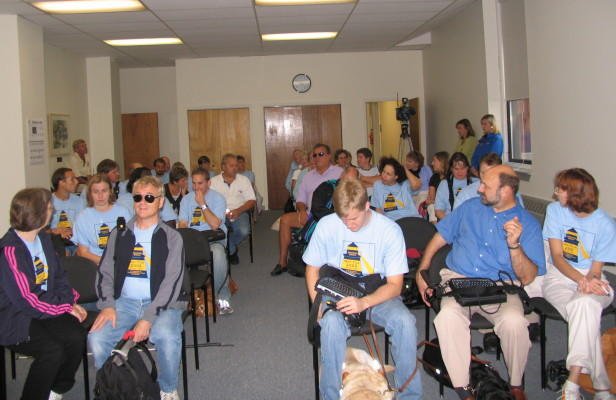

Before leaving the Iris Center, we also managed to wrangle our way onto local TV news and to pose for a few pictures. My personal favorite is the line up of all the Way Fun dog guide teams, eleven of us, in all.
After a relaxed lunch and a few final hours in Portland, most of the group loaded onto a bus headed for the city that will host us for the remainder of our adventure, Bar Harbor, and some of the State’s most beautiful coastline.
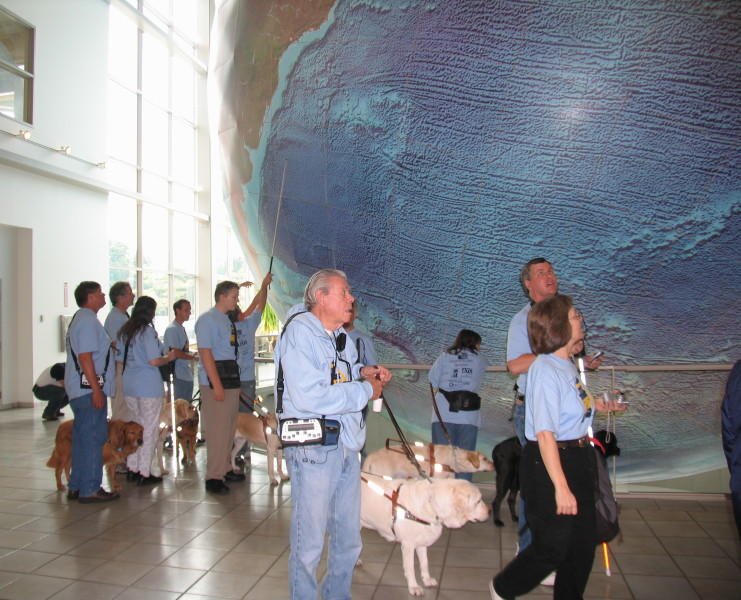
On the way, the gang stopped for another quick picture at the head quarters of DeLorme, the company that produces the GPS receivers that many of us use. The background of the picture—a giant globe—seems somewhat symbolic. Not only does it represent the world-wide scope of the satellites’ eye, but it also serves as a reminder of the international contributions that have led to the creation of the technology we are all using this week: a technology created by one man from the Western United States and another from Canada, now coupled with the products of a company born in New Zealand, and utilized by blind people from California to the Netherlands.

I actually did not ride along with the rest of the group. Instead I tagged along in a van with one of the many staff members from the Seeing Eye which allowed me to put the vehicular route capabilities of my GPS unit to the test. Looking back, it strikes me that our car, too, illustrated some of what has made the technology and independence revolution for blind people possible. Among us, there was a sighted woman born and bred in New England who had dedicated her life to enhancing the travel skills of blind people by training Seeing Eye dogs, a young blind, black professional woman raised in Arkansas and now transplanted to Washington, D.C. where she works for NASA, and me, a Midwestern turned southern grad student just trying to absorb the diversity in experience and knowledge of our group. We are all very different in terms of training, background, and geography, yet we have a common drive that pushes us towards the same goal of greater freedom for ourselves and other visually-impaired people.
Perhaps an alternate theme for our trip could be, “Not everything worth finding can be tracked by GPS.” This is certainly one point that has been especially relevant for me. Once in Bar Harbor, for example, we were able to easily locate a nearby restaurant and travel to it using our equipment. However, it was what we found inside the restaurant that made the greatest impression on me. More important than any Point of Interest cataloged in the GPS software, I had the fortunate occasion to sit and enjoy the company of successful and accomplished blind people who have been blessed with incredible vision. Their experiences and reputations speak volumes, and their patience to sit and listen as I vented my frustrations and theories demonstrated the extent of their wisdom. It is the people that make Way Fun worthwhile, and GPS techniques and commands are only a few of the important lessons they have shared with me this week.
Jamie Dean, Wake Forest University, Winston-Salem North Carolina
Thursday, September 15, 2005
Day 1 Way Fun 2005 Portland, Maine
WayFun 2005
My roommate Denna and I dragged ourselves out of bed around eight o'clock this morning. Since we had been out fairly late the night before (using our GPS units to track down some late night ice cream), getting out of bed took some effort.
We met up with the rest of our traveling companions in the lobby of the hotel around eight thirty. Once everyone had arrived and we had gone over some logistical details, we broke up into small groups according to our level of experience and proficiency with the BrilleNote GPS. Because this was my first time using the GPS, I went with a group of three other new users. We spent about two hours learning the basic functions and keystrokes that one needs to know in order to use the GPS. The leader of our group was Carl, who does technical support and new user training for Sendero Group. By the time our class was finished, everyone in the group knew enough about the GPS units to begin using them on our travels around Portland.
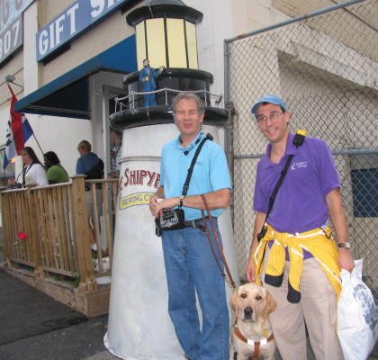
After lunch, several of us decided to go to the Shipyard Brewery. Some of our other traveling companions had had Shipyard beer at the restaurant where they'd eaten lunch and they highly recommended that a group of us go check it out. So, about fifteen of us braved the light rain that had begun to fall and walked the mile or so to the Shipyard Brewery. With visions of hops and barley dancing in our heads, we all trooped into the brewery. Unbeknownst to me at the time, several of the brewery employees pulled two members of our group aside and told them that they didn't want "all these blind people" going upstairs and taking the tour. After all, they said, their are hoses all over the floor and puddles of water everywhere. Luckily, these two people explained that we would all be using canes or dog guides and that these mobility aids would prevent us from getting any sort of trouble. Things seemed settled and we all trooped in to the waiting room. There were about fifty or sixty people waiting to take the tour. A brewery tour guide came up to the front of the room and announced, "Just so everybody knows, we're going to watch an eight minute film on the brewery and the brewing process. After that, we're going to go upstairs and take a tour. This will involve going up three flights of stairs and there are hoses and puddles of water all over the place. So, you might all want to think about that as you watch the film."
Naturally, all of us knew that this was code for, "Are you blind folks sure you can handle this" So, we all nodded and smiled amiably and sat through the eight minute introductory film. After it had ended, the tour guide came back and informed the audience that guide dogs were not allowed upstairs. We tried explaining to the employees that not allowing the guide dogs to come with their owners was against the law. Welaw. They seemed particularly concerned that the dogs would somehow contaminate their yeast. We reminded them that guide dogs are very well groomed and cared for and that, after all, how could they guarantee that any people who went on the tour had good hygene and were clean? After arguing with them for quite some time, most of the group decided not to go on the tour on principle. However, two guide dog users agreed to leave their dogs downstairs with a friend and go on the tour anyway. Being a cane user, I decided to join them. So, Jamie took the tour guide's arm and Denna took my arm and we were off. I was still seething, but I wanted to see what about the brewery floor was so treacherous and frightening. I can honestly say that there was no reason the dogs couldn't have gone. We were never in contact with any of the actual product and, as I said, they don't screen people for cleanliness and all of the guide dogs were probably better groomed then some of the people who take the tour.

Because we had been treated with such disrespect, none of us bought anything from the gift shop and Mike May called the Seeing Eye to look into the matter. Apparently, another guide dog user had once been denied access into a brewery and the court had found them to be guilty of discrimination. We wished we had known this when we went in, but we warned them that they have not seen the last of us. If anybody feels so moved to Google the Shipyard Brewery in Portland, Maine and let them know that they will not be receiving your business or that of your family and friends, that might be nice.
On the way back to the hotel, it started raining buckets. Although none of us were afraid of melting, we were all carrying BrailleNotes and mPowers and other notetakers, so we tried to find some shelter as fast as we could. We ended up ducking into the tax collector's office at the Portland City Hall and waiting out the rain. The people in the office were very friendly and welcoming and I think they got a big kick out of everyone running in their drenched with our canes and guide dogs.

That evening, we all got together as a group for happy hour at the hotel bar and then four of us went out to celebrate Adam's birthday at a restaurant called Three Dollar Dewey's. It's funny, but we were joking on the way about whether or not Sendero Group lists "houses of ill repute" on their list of points of interest. As it turns out, Three Dollar Dewey's used to be a brothel!!! Talk about a strange coincidence! The name of the place comes from the expression, "One dollar, lookee; two dollars, feelee: three dollars, do-ee." However, now Three Dollar Dewey's is just a cozy little pub that serves fish and chips. It was Adam's twenty third birthday, so they brought us all a huge Toll House cookie with ice cream and spoons for all of us. Tomorrow, we're going to demonstrate the GPS to some local blind people, so we have to be up early. It's been a long, full day, so many of us are turning in a little early. We're all really looking forward to going to Bar Harbor tomorrow.
Stacy Cervenka, Minneapolis, MN
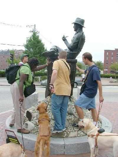
Note: Another group successfully accomplished the task of finding a "geo cache." This is a lat/lon with a clue, in this case it was "the Director" who happened to be John Ford, one of Portland's native sons.
Archives
August 1997 January 1998 August 1999 December 1999 January 2000 September 2004 October 2004 November 2004 December 2004 March 2005 May 2005 July 2005 August 2005 September 2005 November 2005 May 2006 June 2006 August 2006 September 2006 October 2006 November 2006 December 2006 February 2007 March 2007 April 2007 May 2007 July 2007 August 2007 September 2007 October 2007 November 2007 December 2007 January 2008 February 2008 March 2008 May 2008 June 2008 July 2008 August 2008 October 2008 January 2009 June 2009 July 2009 August 2009 September 2009 October 2009 November 2009 December 2009 January 2010 March 2010 April 2010 July 2010 October 2010 December 2010 February 2011 May 2011 July 2011 September 2011 October 2011 November 2011 January 2012 February 2012 March 2012 April 2012 May 2012 July 2012 August 2012 October 2012 November 2012 December 2012 January 2013 March 2013 June 2013 July 2013 August 2013 September 2013 October 2013 November 2013 December 2013 January 2014 March 2014 April 2014 August 2014 September 2014 October 2014 November 2014 December 2014 February 2015 July 2015 August 2015 September 2015 November 2015 December 2015 January 2016 January 2017 September 2018 November 2018
![]()